
München
80469 München-Ludwigsvorstadt-Isarvorstadt, Deutschland
Braunauer Eisenbahnbrücke | Pedestrians & Photos
The Braunauer Eisenbahnbrücke is one of the Munich structures that is often only noticed in passing in everyday life, but whose significance becomes immediately visible as soon as one looks closer. It spans the Isar in the southern city center area, is still an active railway bridge of Deutsche Bahn, and is currently treated in urban documents as a project with a future because its potential repurposing for pedestrian and cycling traffic is being examined. This combination of historical infrastructure, current use, and future vision makes the bridge so interesting for inquiries about pedestrian access, photos, maps, and background information. Therefore, those searching for the Braunauer Eisenbahnbrücke are not just looking for a structure but a piece of Munich's urban history, a crossing over the Isar, and an important question: How can a purely railway crossing one day also become a public urban space? ([muenchen.travel](https://www.muenchen.travel/artikel/stadt-viertel/bruecken-muenchen))
Why the Braunauer Eisenbahnbrücke is primarily searched for regarding pedestrian issues today
The most common inquiries about the Braunauer Eisenbahnbrücke revolve around pedestrians, cycling traffic, and the question of whether the bridge can even be accessed. The Munich tourism portal clearly states that the Braunauer Eisenbahnbrücke cannot be crossed by pedestrians and that only trains run there. At the same time, the city of Munich has been working for years on the idea of opening the northern superstructure of the bridge long-term for pedestrian and cycling traffic. The current city hall review even explicitly states that a feasibility study has confirmed the structural feasibility, but further planning depends on the transfer of use by Deutsche Bahn. Thus, the bridge is a typical example of Munich infrastructure that is no longer just a traffic structure but is also envisioned as a possible urban space and connection between neighborhoods. ([muenchen.travel](https://www.muenchen.travel/artikel/stadt-viertel/bruecken-muenchen))
For the perception of the bridge, this status is crucial: Today it is not a pedestrian bridge but a railway bridge with ongoing train operations. At the same time, it has long been part of the public discussion as a possible pedestrian and cycling connection. This makes it a place where one can observe the transformation of the city well. Visitors searching for Braunauer Eisenbahnbrücke pedestrians or Braunauer Eisenbahnbrücke cycling traffic are usually interested not only in the current state but also in the future plan. That is why the bridge should not be viewed as a completed object but as a project with strong symbolic power: It stands for the connection of railway tradition, Isar space, and urban mobility in the coming years. ([muenchen.travel](https://www.muenchen.travel/artikel/stadt-viertel/bruecken-muenchen))
Where is the Braunauer Eisenbahnbrücke located on maps and how does the location fit into Munich?
On maps and in Munich orientations, the Braunauer Eisenbahnbrücke is located in the southern city center area over the Isar and today belongs to the district 02 Ludwigsvorstadt-Isarvorstadt. The official Munich cultural history publication assigns it together with other southern adjacent city center bridges to this district and shows how strongly the area was shaped by the development of the 19th century. The IBA page of the city explicitly refers to it as a railway bridge of Deutsche Bahn in the Munich city area that spans the Isar. This is the most important anchor for map research: Those entering Braunauer Eisenbahnbrücke in maps are looking for a structure in the Isar area, not a place, a train station, or an event location. ([stadt.muenchen.de](https://stadt.muenchen.de/dam/jcr%3A3bcb5427-0737-4d21-a9bf-7e82e9891db7/KGP02_booklet_3auf_screen.pdf))
Local orientation regarding this bridge primarily means thinking about the river space and the surrounding paths. The Munich city page on the Isar marks the bridge as a reference point in several sections, such as at the bathing zones and the adjacent riverbanks. This makes it clear that the Braunauer Eisenbahnbrücke does not stand in isolation but is part of a densely used inner-city river space. Those preparing on maps should therefore not only search for the bridge itself but also for the neighboring Isar sections, the river paths, and the crossings towards Wittelsbacher Brücke, Reichenbachbrücke, and Flaucher. The bridge is less a destination for staying on it but a prominent landmark in the Munich Isar course. ([stadt.muenchen.de](https://stadt.muenchen.de/infos/isar.html))
History of the Braunauer Eisenbahnbrücke since 1869
Historically, the Braunauer Eisenbahnbrücke is a product of the Munich railway expansion in the 19th century. The official cultural history publication of the city states that it was built in 1869 as part of the belt railway construction over the Isar. Thus, it is not a late supplementary structure but part of that significant phase in which Munich developed its modern transport and industrial infrastructure. This period is particularly formative for urban development around the Isar: The railway lines connected the main station with new stations, freight flows, and districts, and the bridges became permanent interventions in the cityscape. The Braunauer Eisenbahnbrücke is therefore one of the structures where the transition from historic Munich to the railway city is particularly evident. ([stadt.muenchen.de](https://stadt.muenchen.de/dam/jcr%3A3bcb5427-0737-4d21-a9bf-7e82e9891db7/KGP02_booklet_3auf_screen.pdf))
Important is also the urban planning classification. The official city material shows that the southern adjacent city center bridges like Bosch-, Cornelius-, Reichenbach-, Wittelsbacher-, and Braunauer Eisenbahnbrücke are perceived today as a cohesive bridge landscape. The Braunauer Eisenbahnbrücke thus does not stand alone but in a series of Isar crossings that shape the image of southern Munich. That it is still used in rail traffic today underscores its technical continuity: It is not a museum relic but a functioning part of the rail network. This combination of historical origin, ongoing use, and public debate makes the bridge equally exciting from the perspective of SEO and urban history. ([stadt.muenchen.de](https://stadt.muenchen.de/dam/jcr%3A3bcb5427-0737-4d21-a9bf-7e82e9891db7/KGP02_booklet_3auf_screen.pdf))
For readers looking for Braunauer Eisenbahnbrücke history, it is also important: The name always stands in Munich for the larger topic of Isar bridges and urban growth. The bridge marks a point where mobility, river landscape, and urban development intersect. Those viewing it today see not only steel and tracks but a 150-year-old idea of city connection that still works and is being rethought. This is precisely where its appeal lies: It is historically, technically, and politically relevant at the same time. ([stadt.muenchen.de](https://stadt.muenchen.de/dam/jcr%3A3bcb5427-0737-4d21-a9bf-7e82e9891db7/KGP02_booklet_3auf_screen.pdf))
Isar, Swimming, and Barbecuing around the Braunauer Eisenbahnbrücke
The area around the Braunauer Eisenbahnbrücke is not only a traffic corridor but also part of the Munich Isar area with clearly regulated recreational use. The official city page on the Isar names the bridge as an important reference point for bathing zones and river sections. Particularly relevant is that swimming is allowed in certain sections of the Isar, including on the eastern riverbank from the Braunauer Eisenbahnbrücke to just before the Wittelsbacher Brücke. At the same time, the city explicitly points out that swimming near dam and turbine facilities, weirs, locks, and other danger spots is prohibited. For visitors, this means: The Isar area is attractive but not arbitrarily usable; it is regulated by safety rules and nature or water protection. ([stadt.muenchen.de](https://stadt.muenchen.de/infos/isar.html))
The regulations for barbecuing are even stricter. The city of Munich states that barbecuing is not allowed in the entire inner-city area from the Brudermühlbrücke to the Oberföhringer Wehr, including around the Braunauer Eisenbahnbrücke. Swimming in the Isar is only permitted in designated areas; the city names, among other things, sections from the Braunauer Eisenbahnbrücke to just before the Wittelsbacher Brücke on the eastern riverbank. ([stadt.muenchen.de](https://stadt.muenchen.de/infos/grillen-stadt.html))
It is precisely this mixture that creates the special character of the location. The Braunauer Eisenbahnbrücke is located at a section of the Isar that is appreciated for walks, cycling, and quiet stays by the water. This is also reflected in the fact that the city includes the section as part of its bathing map and recreational information. Those moving here experience Munich not as a pure car city but as a city by the river, where bridges, riverbanks, and open spaces belong together. This is why the Braunauer Eisenbahnbrücke is an attractive search term for people who want to understand nature, city, and infrastructure simultaneously. ([stadt.muenchen.de](https://stadt.muenchen.de/infos/isar.html))
Kiosks, Paths, and the Experience on Site at the Braunauer Eisenbahnbrücke
Those visiting the surroundings of the Braunauer Eisenbahnbrücke often look not only for history but also for practical things like a small break, a path by the water, or simple orientation. On the barrier-free Isar side of Munich tourism, kiosks at the Wittelsbacher Brücke, the Braunauer Eisenbahnbrücke, and the Thalkirchner Brücke are mentioned. This is a valuable hint for all who want to stay in the Isar area: The bridge is part of a lively river section where one can not only pass by but also find small supply and break offers. Particularly for inquiries with the term kiosk, this is relevant because the bridge itself does not serve as a gastronomic location but is located in the vicinity of a river section where such offers are available. ([muenchen-barrierefrei.de](https://muenchen-barrierefrei.de/isar/))
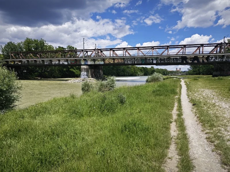
The path guidance around the bridge is also important. The Munich tourism portal describes that it continues under the Braunauer Eisenbahnbrücke towards Flaucher. This makes the bridge a link between the inner-city Isar area and the southern recreational river space. One does not experience an isolated point here but a continuation of the walk along the water. For visitors interested in photos or maps, this means: The bridge is particularly well understood as part of a route, not just as a single motif. Those walking along the bank can see the bridge repeatedly from different angles as the river, gravel areas, and paths open further south. This is where its appeal as a place of movement and transition arises. ([muenchen.travel](https://www.muenchen.travel/artikel/stadt-viertel/bruecken-muenchen))
The practical value of the location lies not in a classic visitor infrastructure like a parking deck or event operation but in its embedding in the Munich Isar area. The environment is ideal for walks, short stops, and observations of the railway and river space. In SEO language, the term Braunauer Eisenbahnbrücke photos fits particularly well here because the bridge appears visually very striking due to its active rail function and its location on the Isar. For many users, it is a place where Munich is not staged but shows itself quite naturally: as a city of bridges, riverbanks, tracks, and paths. ([muenchen.travel](https://www.muenchen.travel/artikel/stadt-viertel/bruecken-muenchen))
Photos, Views, and the Future as a Pedestrian and Cycling Bridge
The Braunauer Eisenbahnbrücke is particularly interesting from a photographic perspective because it does not function as a freely accessible structure but is perceived from a distance. This makes it attractive for photos and inquiries: It can be seen from river paths, neighboring bridges, and from the Isar area as a clear technical contrast to nature. The Munich tourism portal visibly locates it in a gallery of Isar bridges and simultaneously shows that it is currently a purely railway structure. For the city's imagery, this is important because the bridge does not stand for crossing on foot but for the view of a piece of Munich that is outlined between river, tracks, and riverbank. ([muenchen.travel](https://www.muenchen.travel/artikel/stadt-viertel/bruecken-muenchen))
However, the future of the bridge is just as relevant as its current appearance. In the city hall review from April 2026, the city of Munich informs that the Braunauer Eisenbahnbrücke is being pursued as a project for pedestrian and cycling connection as part of the International Building Exhibition. According to the city, a feasibility study for the repurposing of the northern superstructure has been conducted; the results show that structural implementation is fundamentally possible. At the same time, it is openly stated that further planning is dependent on the transfer of use by Deutsche Bahn, and the Federal Railway Authority has not yet indicated a permanent transfer. This means: The vision is real, but it is not yet completed. ([ru.muenchen.de](https://ru.muenchen.de/2026/71/Bauausschuss-entscheidet-ueber-IBA-Projekte-123830))
This is precisely where the special story of this bridge lies. It is not only a monument of railway history but also an example of how Munich's infrastructure could change in the future. Those searching for photos receive a bridge that today connects rail traffic, river landscape, and city panorama. Those searching for the future receive a project that rethinks mobility and may one day open the space above the Isar for pedestrians and cyclists as well. For the search intent Braunauer Eisenbahnbrücke Munich, this dual perspective is the key: Past and future are only a few meters apart here. ([stadt.muenchen.de](https://stadt.muenchen.de/dam/jcr%3A3bcb5427-0737-4d21-a9bf-7e82e9891db7/KGP02_booklet_3auf_screen.pdf))
The Braunauer Eisenbahnbrücke thus remains a fascinating Munich structure because it embodies function, memory, and possibility at the same time. It is today an active part of the rail network, a prominent landmark on the Isar bank, and a much-discussed future project. Those searching for it on maps seek orientation. Those searching for photos seek perspective. Those searching for pedestrians seek change. These three levels make the bridge one of the most exciting infrastructure topics in southern Munich. ([muenchen.travel](https://www.muenchen.travel/artikel/stadt-viertel/bruecken-muenchen))
Sources:
Mehr anzeigenWeniger anzeigen
Braunauer Eisenbahnbrücke | Pedestrians & Photos
The Braunauer Eisenbahnbrücke is one of the Munich structures that is often only noticed in passing in everyday life, but whose significance becomes immediately visible as soon as one looks closer. It spans the Isar in the southern city center area, is still an active railway bridge of Deutsche Bahn, and is currently treated in urban documents as a project with a future because its potential repurposing for pedestrian and cycling traffic is being examined. This combination of historical infrastructure, current use, and future vision makes the bridge so interesting for inquiries about pedestrian access, photos, maps, and background information. Therefore, those searching for the Braunauer Eisenbahnbrücke are not just looking for a structure but a piece of Munich's urban history, a crossing over the Isar, and an important question: How can a purely railway crossing one day also become a public urban space? ([muenchen.travel](https://www.muenchen.travel/artikel/stadt-viertel/bruecken-muenchen))
Why the Braunauer Eisenbahnbrücke is primarily searched for regarding pedestrian issues today
The most common inquiries about the Braunauer Eisenbahnbrücke revolve around pedestrians, cycling traffic, and the question of whether the bridge can even be accessed. The Munich tourism portal clearly states that the Braunauer Eisenbahnbrücke cannot be crossed by pedestrians and that only trains run there. At the same time, the city of Munich has been working for years on the idea of opening the northern superstructure of the bridge long-term for pedestrian and cycling traffic. The current city hall review even explicitly states that a feasibility study has confirmed the structural feasibility, but further planning depends on the transfer of use by Deutsche Bahn. Thus, the bridge is a typical example of Munich infrastructure that is no longer just a traffic structure but is also envisioned as a possible urban space and connection between neighborhoods. ([muenchen.travel](https://www.muenchen.travel/artikel/stadt-viertel/bruecken-muenchen))
For the perception of the bridge, this status is crucial: Today it is not a pedestrian bridge but a railway bridge with ongoing train operations. At the same time, it has long been part of the public discussion as a possible pedestrian and cycling connection. This makes it a place where one can observe the transformation of the city well. Visitors searching for Braunauer Eisenbahnbrücke pedestrians or Braunauer Eisenbahnbrücke cycling traffic are usually interested not only in the current state but also in the future plan. That is why the bridge should not be viewed as a completed object but as a project with strong symbolic power: It stands for the connection of railway tradition, Isar space, and urban mobility in the coming years. ([muenchen.travel](https://www.muenchen.travel/artikel/stadt-viertel/bruecken-muenchen))
Where is the Braunauer Eisenbahnbrücke located on maps and how does the location fit into Munich?
On maps and in Munich orientations, the Braunauer Eisenbahnbrücke is located in the southern city center area over the Isar and today belongs to the district 02 Ludwigsvorstadt-Isarvorstadt. The official Munich cultural history publication assigns it together with other southern adjacent city center bridges to this district and shows how strongly the area was shaped by the development of the 19th century. The IBA page of the city explicitly refers to it as a railway bridge of Deutsche Bahn in the Munich city area that spans the Isar. This is the most important anchor for map research: Those entering Braunauer Eisenbahnbrücke in maps are looking for a structure in the Isar area, not a place, a train station, or an event location. ([stadt.muenchen.de](https://stadt.muenchen.de/dam/jcr%3A3bcb5427-0737-4d21-a9bf-7e82e9891db7/KGP02_booklet_3auf_screen.pdf))
Local orientation regarding this bridge primarily means thinking about the river space and the surrounding paths. The Munich city page on the Isar marks the bridge as a reference point in several sections, such as at the bathing zones and the adjacent riverbanks. This makes it clear that the Braunauer Eisenbahnbrücke does not stand in isolation but is part of a densely used inner-city river space. Those preparing on maps should therefore not only search for the bridge itself but also for the neighboring Isar sections, the river paths, and the crossings towards Wittelsbacher Brücke, Reichenbachbrücke, and Flaucher. The bridge is less a destination for staying on it but a prominent landmark in the Munich Isar course. ([stadt.muenchen.de](https://stadt.muenchen.de/infos/isar.html))
History of the Braunauer Eisenbahnbrücke since 1869
Historically, the Braunauer Eisenbahnbrücke is a product of the Munich railway expansion in the 19th century. The official cultural history publication of the city states that it was built in 1869 as part of the belt railway construction over the Isar. Thus, it is not a late supplementary structure but part of that significant phase in which Munich developed its modern transport and industrial infrastructure. This period is particularly formative for urban development around the Isar: The railway lines connected the main station with new stations, freight flows, and districts, and the bridges became permanent interventions in the cityscape. The Braunauer Eisenbahnbrücke is therefore one of the structures where the transition from historic Munich to the railway city is particularly evident. ([stadt.muenchen.de](https://stadt.muenchen.de/dam/jcr%3A3bcb5427-0737-4d21-a9bf-7e82e9891db7/KGP02_booklet_3auf_screen.pdf))
Important is also the urban planning classification. The official city material shows that the southern adjacent city center bridges like Bosch-, Cornelius-, Reichenbach-, Wittelsbacher-, and Braunauer Eisenbahnbrücke are perceived today as a cohesive bridge landscape. The Braunauer Eisenbahnbrücke thus does not stand alone but in a series of Isar crossings that shape the image of southern Munich. That it is still used in rail traffic today underscores its technical continuity: It is not a museum relic but a functioning part of the rail network. This combination of historical origin, ongoing use, and public debate makes the bridge equally exciting from the perspective of SEO and urban history. ([stadt.muenchen.de](https://stadt.muenchen.de/dam/jcr%3A3bcb5427-0737-4d21-a9bf-7e82e9891db7/KGP02_booklet_3auf_screen.pdf))
For readers looking for Braunauer Eisenbahnbrücke history, it is also important: The name always stands in Munich for the larger topic of Isar bridges and urban growth. The bridge marks a point where mobility, river landscape, and urban development intersect. Those viewing it today see not only steel and tracks but a 150-year-old idea of city connection that still works and is being rethought. This is precisely where its appeal lies: It is historically, technically, and politically relevant at the same time. ([stadt.muenchen.de](https://stadt.muenchen.de/dam/jcr%3A3bcb5427-0737-4d21-a9bf-7e82e9891db7/KGP02_booklet_3auf_screen.pdf))
Isar, Swimming, and Barbecuing around the Braunauer Eisenbahnbrücke
The area around the Braunauer Eisenbahnbrücke is not only a traffic corridor but also part of the Munich Isar area with clearly regulated recreational use. The official city page on the Isar names the bridge as an important reference point for bathing zones and river sections. Particularly relevant is that swimming is allowed in certain sections of the Isar, including on the eastern riverbank from the Braunauer Eisenbahnbrücke to just before the Wittelsbacher Brücke. At the same time, the city explicitly points out that swimming near dam and turbine facilities, weirs, locks, and other danger spots is prohibited. For visitors, this means: The Isar area is attractive but not arbitrarily usable; it is regulated by safety rules and nature or water protection. ([stadt.muenchen.de](https://stadt.muenchen.de/infos/isar.html))
The regulations for barbecuing are even stricter. The city of Munich states that barbecuing is not allowed in the entire inner-city area from the Brudermühlbrücke to the Oberföhringer Wehr, including around the Braunauer Eisenbahnbrücke. Swimming in the Isar is only permitted in designated areas; the city names, among other things, sections from the Braunauer Eisenbahnbrücke to just before the Wittelsbacher Brücke on the eastern riverbank. ([stadt.muenchen.de](https://stadt.muenchen.de/infos/grillen-stadt.html))
It is precisely this mixture that creates the special character of the location. The Braunauer Eisenbahnbrücke is located at a section of the Isar that is appreciated for walks, cycling, and quiet stays by the water. This is also reflected in the fact that the city includes the section as part of its bathing map and recreational information. Those moving here experience Munich not as a pure car city but as a city by the river, where bridges, riverbanks, and open spaces belong together. This is why the Braunauer Eisenbahnbrücke is an attractive search term for people who want to understand nature, city, and infrastructure simultaneously. ([stadt.muenchen.de](https://stadt.muenchen.de/infos/isar.html))
Kiosks, Paths, and the Experience on Site at the Braunauer Eisenbahnbrücke
Those visiting the surroundings of the Braunauer Eisenbahnbrücke often look not only for history but also for practical things like a small break, a path by the water, or simple orientation. On the barrier-free Isar side of Munich tourism, kiosks at the Wittelsbacher Brücke, the Braunauer Eisenbahnbrücke, and the Thalkirchner Brücke are mentioned. This is a valuable hint for all who want to stay in the Isar area: The bridge is part of a lively river section where one can not only pass by but also find small supply and break offers. Particularly for inquiries with the term kiosk, this is relevant because the bridge itself does not serve as a gastronomic location but is located in the vicinity of a river section where such offers are available. ([muenchen-barrierefrei.de](https://muenchen-barrierefrei.de/isar/))
The path guidance around the bridge is also important. The Munich tourism portal describes that it continues under the Braunauer Eisenbahnbrücke towards Flaucher. This makes the bridge a link between the inner-city Isar area and the southern recreational river space. One does not experience an isolated point here but a continuation of the walk along the water. For visitors interested in photos or maps, this means: The bridge is particularly well understood as part of a route, not just as a single motif. Those walking along the bank can see the bridge repeatedly from different angles as the river, gravel areas, and paths open further south. This is where its appeal as a place of movement and transition arises. ([muenchen.travel](https://www.muenchen.travel/artikel/stadt-viertel/bruecken-muenchen))
The practical value of the location lies not in a classic visitor infrastructure like a parking deck or event operation but in its embedding in the Munich Isar area. The environment is ideal for walks, short stops, and observations of the railway and river space. In SEO language, the term Braunauer Eisenbahnbrücke photos fits particularly well here because the bridge appears visually very striking due to its active rail function and its location on the Isar. For many users, it is a place where Munich is not staged but shows itself quite naturally: as a city of bridges, riverbanks, tracks, and paths. ([muenchen.travel](https://www.muenchen.travel/artikel/stadt-viertel/bruecken-muenchen))
Photos, Views, and the Future as a Pedestrian and Cycling Bridge
The Braunauer Eisenbahnbrücke is particularly interesting from a photographic perspective because it does not function as a freely accessible structure but is perceived from a distance. This makes it attractive for photos and inquiries: It can be seen from river paths, neighboring bridges, and from the Isar area as a clear technical contrast to nature. The Munich tourism portal visibly locates it in a gallery of Isar bridges and simultaneously shows that it is currently a purely railway structure. For the city's imagery, this is important because the bridge does not stand for crossing on foot but for the view of a piece of Munich that is outlined between river, tracks, and riverbank. ([muenchen.travel](https://www.muenchen.travel/artikel/stadt-viertel/bruecken-muenchen))
However, the future of the bridge is just as relevant as its current appearance. In the city hall review from April 2026, the city of Munich informs that the Braunauer Eisenbahnbrücke is being pursued as a project for pedestrian and cycling connection as part of the International Building Exhibition. According to the city, a feasibility study for the repurposing of the northern superstructure has been conducted; the results show that structural implementation is fundamentally possible. At the same time, it is openly stated that further planning is dependent on the transfer of use by Deutsche Bahn, and the Federal Railway Authority has not yet indicated a permanent transfer. This means: The vision is real, but it is not yet completed. ([ru.muenchen.de](https://ru.muenchen.de/2026/71/Bauausschuss-entscheidet-ueber-IBA-Projekte-123830))
This is precisely where the special story of this bridge lies. It is not only a monument of railway history but also an example of how Munich's infrastructure could change in the future. Those searching for photos receive a bridge that today connects rail traffic, river landscape, and city panorama. Those searching for the future receive a project that rethinks mobility and may one day open the space above the Isar for pedestrians and cyclists as well. For the search intent Braunauer Eisenbahnbrücke Munich, this dual perspective is the key: Past and future are only a few meters apart here. ([stadt.muenchen.de](https://stadt.muenchen.de/dam/jcr%3A3bcb5427-0737-4d21-a9bf-7e82e9891db7/KGP02_booklet_3auf_screen.pdf))
The Braunauer Eisenbahnbrücke thus remains a fascinating Munich structure because it embodies function, memory, and possibility at the same time. It is today an active part of the rail network, a prominent landmark on the Isar bank, and a much-discussed future project. Those searching for it on maps seek orientation. Those searching for photos seek perspective. Those searching for pedestrians seek change. These three levels make the bridge one of the most exciting infrastructure topics in southern Munich. ([muenchen.travel](https://www.muenchen.travel/artikel/stadt-viertel/bruecken-muenchen))
Sources:
Braunauer Eisenbahnbrücke | Pedestrians & Photos
The Braunauer Eisenbahnbrücke is one of the Munich structures that is often only noticed in passing in everyday life, but whose significance becomes immediately visible as soon as one looks closer. It spans the Isar in the southern city center area, is still an active railway bridge of Deutsche Bahn, and is currently treated in urban documents as a project with a future because its potential repurposing for pedestrian and cycling traffic is being examined. This combination of historical infrastructure, current use, and future vision makes the bridge so interesting for inquiries about pedestrian access, photos, maps, and background information. Therefore, those searching for the Braunauer Eisenbahnbrücke are not just looking for a structure but a piece of Munich's urban history, a crossing over the Isar, and an important question: How can a purely railway crossing one day also become a public urban space? ([muenchen.travel](https://www.muenchen.travel/artikel/stadt-viertel/bruecken-muenchen))
Why the Braunauer Eisenbahnbrücke is primarily searched for regarding pedestrian issues today
The most common inquiries about the Braunauer Eisenbahnbrücke revolve around pedestrians, cycling traffic, and the question of whether the bridge can even be accessed. The Munich tourism portal clearly states that the Braunauer Eisenbahnbrücke cannot be crossed by pedestrians and that only trains run there. At the same time, the city of Munich has been working for years on the idea of opening the northern superstructure of the bridge long-term for pedestrian and cycling traffic. The current city hall review even explicitly states that a feasibility study has confirmed the structural feasibility, but further planning depends on the transfer of use by Deutsche Bahn. Thus, the bridge is a typical example of Munich infrastructure that is no longer just a traffic structure but is also envisioned as a possible urban space and connection between neighborhoods. ([muenchen.travel](https://www.muenchen.travel/artikel/stadt-viertel/bruecken-muenchen))
For the perception of the bridge, this status is crucial: Today it is not a pedestrian bridge but a railway bridge with ongoing train operations. At the same time, it has long been part of the public discussion as a possible pedestrian and cycling connection. This makes it a place where one can observe the transformation of the city well. Visitors searching for Braunauer Eisenbahnbrücke pedestrians or Braunauer Eisenbahnbrücke cycling traffic are usually interested not only in the current state but also in the future plan. That is why the bridge should not be viewed as a completed object but as a project with strong symbolic power: It stands for the connection of railway tradition, Isar space, and urban mobility in the coming years. ([muenchen.travel](https://www.muenchen.travel/artikel/stadt-viertel/bruecken-muenchen))
Where is the Braunauer Eisenbahnbrücke located on maps and how does the location fit into Munich?
On maps and in Munich orientations, the Braunauer Eisenbahnbrücke is located in the southern city center area over the Isar and today belongs to the district 02 Ludwigsvorstadt-Isarvorstadt. The official Munich cultural history publication assigns it together with other southern adjacent city center bridges to this district and shows how strongly the area was shaped by the development of the 19th century. The IBA page of the city explicitly refers to it as a railway bridge of Deutsche Bahn in the Munich city area that spans the Isar. This is the most important anchor for map research: Those entering Braunauer Eisenbahnbrücke in maps are looking for a structure in the Isar area, not a place, a train station, or an event location. ([stadt.muenchen.de](https://stadt.muenchen.de/dam/jcr%3A3bcb5427-0737-4d21-a9bf-7e82e9891db7/KGP02_booklet_3auf_screen.pdf))
Local orientation regarding this bridge primarily means thinking about the river space and the surrounding paths. The Munich city page on the Isar marks the bridge as a reference point in several sections, such as at the bathing zones and the adjacent riverbanks. This makes it clear that the Braunauer Eisenbahnbrücke does not stand in isolation but is part of a densely used inner-city river space. Those preparing on maps should therefore not only search for the bridge itself but also for the neighboring Isar sections, the river paths, and the crossings towards Wittelsbacher Brücke, Reichenbachbrücke, and Flaucher. The bridge is less a destination for staying on it but a prominent landmark in the Munich Isar course. ([stadt.muenchen.de](https://stadt.muenchen.de/infos/isar.html))
History of the Braunauer Eisenbahnbrücke since 1869
Historically, the Braunauer Eisenbahnbrücke is a product of the Munich railway expansion in the 19th century. The official cultural history publication of the city states that it was built in 1869 as part of the belt railway construction over the Isar. Thus, it is not a late supplementary structure but part of that significant phase in which Munich developed its modern transport and industrial infrastructure. This period is particularly formative for urban development around the Isar: The railway lines connected the main station with new stations, freight flows, and districts, and the bridges became permanent interventions in the cityscape. The Braunauer Eisenbahnbrücke is therefore one of the structures where the transition from historic Munich to the railway city is particularly evident. ([stadt.muenchen.de](https://stadt.muenchen.de/dam/jcr%3A3bcb5427-0737-4d21-a9bf-7e82e9891db7/KGP02_booklet_3auf_screen.pdf))
Important is also the urban planning classification. The official city material shows that the southern adjacent city center bridges like Bosch-, Cornelius-, Reichenbach-, Wittelsbacher-, and Braunauer Eisenbahnbrücke are perceived today as a cohesive bridge landscape. The Braunauer Eisenbahnbrücke thus does not stand alone but in a series of Isar crossings that shape the image of southern Munich. That it is still used in rail traffic today underscores its technical continuity: It is not a museum relic but a functioning part of the rail network. This combination of historical origin, ongoing use, and public debate makes the bridge equally exciting from the perspective of SEO and urban history. ([stadt.muenchen.de](https://stadt.muenchen.de/dam/jcr%3A3bcb5427-0737-4d21-a9bf-7e82e9891db7/KGP02_booklet_3auf_screen.pdf))
For readers looking for Braunauer Eisenbahnbrücke history, it is also important: The name always stands in Munich for the larger topic of Isar bridges and urban growth. The bridge marks a point where mobility, river landscape, and urban development intersect. Those viewing it today see not only steel and tracks but a 150-year-old idea of city connection that still works and is being rethought. This is precisely where its appeal lies: It is historically, technically, and politically relevant at the same time. ([stadt.muenchen.de](https://stadt.muenchen.de/dam/jcr%3A3bcb5427-0737-4d21-a9bf-7e82e9891db7/KGP02_booklet_3auf_screen.pdf))
Isar, Swimming, and Barbecuing around the Braunauer Eisenbahnbrücke
The area around the Braunauer Eisenbahnbrücke is not only a traffic corridor but also part of the Munich Isar area with clearly regulated recreational use. The official city page on the Isar names the bridge as an important reference point for bathing zones and river sections. Particularly relevant is that swimming is allowed in certain sections of the Isar, including on the eastern riverbank from the Braunauer Eisenbahnbrücke to just before the Wittelsbacher Brücke. At the same time, the city explicitly points out that swimming near dam and turbine facilities, weirs, locks, and other danger spots is prohibited. For visitors, this means: The Isar area is attractive but not arbitrarily usable; it is regulated by safety rules and nature or water protection. ([stadt.muenchen.de](https://stadt.muenchen.de/infos/isar.html))
The regulations for barbecuing are even stricter. The city of Munich states that barbecuing is not allowed in the entire inner-city area from the Brudermühlbrücke to the Oberföhringer Wehr, including around the Braunauer Eisenbahnbrücke. Swimming in the Isar is only permitted in designated areas; the city names, among other things, sections from the Braunauer Eisenbahnbrücke to just before the Wittelsbacher Brücke on the eastern riverbank. ([stadt.muenchen.de](https://stadt.muenchen.de/infos/grillen-stadt.html))
It is precisely this mixture that creates the special character of the location. The Braunauer Eisenbahnbrücke is located at a section of the Isar that is appreciated for walks, cycling, and quiet stays by the water. This is also reflected in the fact that the city includes the section as part of its bathing map and recreational information. Those moving here experience Munich not as a pure car city but as a city by the river, where bridges, riverbanks, and open spaces belong together. This is why the Braunauer Eisenbahnbrücke is an attractive search term for people who want to understand nature, city, and infrastructure simultaneously. ([stadt.muenchen.de](https://stadt.muenchen.de/infos/isar.html))
Kiosks, Paths, and the Experience on Site at the Braunauer Eisenbahnbrücke
Those visiting the surroundings of the Braunauer Eisenbahnbrücke often look not only for history but also for practical things like a small break, a path by the water, or simple orientation. On the barrier-free Isar side of Munich tourism, kiosks at the Wittelsbacher Brücke, the Braunauer Eisenbahnbrücke, and the Thalkirchner Brücke are mentioned. This is a valuable hint for all who want to stay in the Isar area: The bridge is part of a lively river section where one can not only pass by but also find small supply and break offers. Particularly for inquiries with the term kiosk, this is relevant because the bridge itself does not serve as a gastronomic location but is located in the vicinity of a river section where such offers are available. ([muenchen-barrierefrei.de](https://muenchen-barrierefrei.de/isar/))
The path guidance around the bridge is also important. The Munich tourism portal describes that it continues under the Braunauer Eisenbahnbrücke towards Flaucher. This makes the bridge a link between the inner-city Isar area and the southern recreational river space. One does not experience an isolated point here but a continuation of the walk along the water. For visitors interested in photos or maps, this means: The bridge is particularly well understood as part of a route, not just as a single motif. Those walking along the bank can see the bridge repeatedly from different angles as the river, gravel areas, and paths open further south. This is where its appeal as a place of movement and transition arises. ([muenchen.travel](https://www.muenchen.travel/artikel/stadt-viertel/bruecken-muenchen))
The practical value of the location lies not in a classic visitor infrastructure like a parking deck or event operation but in its embedding in the Munich Isar area. The environment is ideal for walks, short stops, and observations of the railway and river space. In SEO language, the term Braunauer Eisenbahnbrücke photos fits particularly well here because the bridge appears visually very striking due to its active rail function and its location on the Isar. For many users, it is a place where Munich is not staged but shows itself quite naturally: as a city of bridges, riverbanks, tracks, and paths. ([muenchen.travel](https://www.muenchen.travel/artikel/stadt-viertel/bruecken-muenchen))
Photos, Views, and the Future as a Pedestrian and Cycling Bridge
The Braunauer Eisenbahnbrücke is particularly interesting from a photographic perspective because it does not function as a freely accessible structure but is perceived from a distance. This makes it attractive for photos and inquiries: It can be seen from river paths, neighboring bridges, and from the Isar area as a clear technical contrast to nature. The Munich tourism portal visibly locates it in a gallery of Isar bridges and simultaneously shows that it is currently a purely railway structure. For the city's imagery, this is important because the bridge does not stand for crossing on foot but for the view of a piece of Munich that is outlined between river, tracks, and riverbank. ([muenchen.travel](https://www.muenchen.travel/artikel/stadt-viertel/bruecken-muenchen))
However, the future of the bridge is just as relevant as its current appearance. In the city hall review from April 2026, the city of Munich informs that the Braunauer Eisenbahnbrücke is being pursued as a project for pedestrian and cycling connection as part of the International Building Exhibition. According to the city, a feasibility study for the repurposing of the northern superstructure has been conducted; the results show that structural implementation is fundamentally possible. At the same time, it is openly stated that further planning is dependent on the transfer of use by Deutsche Bahn, and the Federal Railway Authority has not yet indicated a permanent transfer. This means: The vision is real, but it is not yet completed. ([ru.muenchen.de](https://ru.muenchen.de/2026/71/Bauausschuss-entscheidet-ueber-IBA-Projekte-123830))
This is precisely where the special story of this bridge lies. It is not only a monument of railway history but also an example of how Munich's infrastructure could change in the future. Those searching for photos receive a bridge that today connects rail traffic, river landscape, and city panorama. Those searching for the future receive a project that rethinks mobility and may one day open the space above the Isar for pedestrians and cyclists as well. For the search intent Braunauer Eisenbahnbrücke Munich, this dual perspective is the key: Past and future are only a few meters apart here. ([stadt.muenchen.de](https://stadt.muenchen.de/dam/jcr%3A3bcb5427-0737-4d21-a9bf-7e82e9891db7/KGP02_booklet_3auf_screen.pdf))
The Braunauer Eisenbahnbrücke thus remains a fascinating Munich structure because it embodies function, memory, and possibility at the same time. It is today an active part of the rail network, a prominent landmark on the Isar bank, and a much-discussed future project. Those searching for it on maps seek orientation. Those searching for photos seek perspective. Those searching for pedestrians seek change. These three levels make the bridge one of the most exciting infrastructure topics in southern Munich. ([muenchen.travel](https://www.muenchen.travel/artikel/stadt-viertel/bruecken-muenchen))
Sources:
Frequently Asked Questions
Reviews
No reviews found