
München
Dülferstraße, 80933 München, Deutschland
Dülferstraße | U-Bahn & Route
Dülferstraße is more than just a street name for many search queries: It usually refers to the subway station of the same name in Munich, which is located on the U2 line, classified in Zone M/1, and serves the eastern part of Hasenbergl as well as the area of Panzerwiese. The station and street are named after the mountaineer Hans Dülfer. The MVV describes the station as barrier-free with step-free access; this makes it particularly practical for everyday life, for commuting, and for orientation in northern Munich. ([mvv-muenchen.de](https://www.mvv-muenchen.de/plaene-bahnhoefe/bahnhofsinformation/station/duelferstrasse/index.html))
Those searching for Dülferstraße maps or dülferstraße route usually want to quickly understand how to navigate to the location effectively, which exits are important, and what nearby destinations are available. For this reason, Dülferstraße is a classic anchor point: U2, local bus connections, direct access to mira, and a clear location between Hasenbergl, Harthof, and Panzerwiese make the area in northern Munich easy to find. The search leads not only to a stop but to an entire neighborhood with residential and supply functions. ([mvg.de](https://www.mvg.de/aushangfahrplan/P8_H_DF_0.pdf))
Dülferstraße on the map: Maps, route, and subway connection
For digital orientation, Dülferstraße is a very rewarding search target because the name brings together two levels: the street at the surface and the subway station below. Those planning the route benefit from the fact that the station is located in a clearly named urban area and is listed in the official MVV plans with clear surrounding and platform information. The 24th district Feldmoching-Hasenbergl extends between Schleißheimer Straße in the east, Dachauer Straße in the west, and the DB-Nordring up to the city limits in the north. Right in this northern urban area, Dülferstraße anchors itself as a point of orientation for residents, commuters, and visitors. ([stadt.muenchen.de](https://stadt.muenchen.de/infos/bezirk24_feldmoching-hasenbergl.html))
The current significance of Dülferstraße is closely linked to the history of the U2. According to MVG, the section Scheidplatz–Dülferstraße was opened on November 20, 1993; the extension to Feldmoching followed on October 26, 1996. This explains why the station has long been an important northern endpoint and is still perceived today as a starting or ending point for many routes. Additionally, since 2008, the station has had direct access to the shopping center mira and was expanded in 2002 to include access to Panzerwiese. Thus, a classic subway station has become a very practical connection point between local supply, residential areas, and open spaces. ([mvg.de](https://www.mvg.de/ueber-die-mvg/unsere-fahrzeuge/u-bahn.html?lang=es))
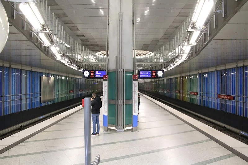
Architecturally, the station also has a clear profile. According to MVG, it was designed by the architect duo Peter Lanz and Jürgen Rauch, with colorful wall designs by Ricarda Dietz. The facility was designed with an intermediate floor, light openings, and a spacious effect to help passengers orient themselves quickly. For the search intent dülferstraße maps, this is relevant because the station is not just a point on the map but a well-readable space with clear exits, visible reference points, and an environment that can be easily understood through plans and maps. ([mvg.de](https://www.mvg.de/aushangfahrplan/P8_H_DF_0.pdf))
With the U2 to Dülferstraße: Access, bus connections, and night traffic
The easiest way to get to Dülferstraße is by U2. This is not only the fastest but also the most intuitive connection, as the station itself is prominently featured in the MVV and MVG information systems. For many users, the question of route is actually a transfer question: Which way gets me to the U2 the fastest, and which exit takes me further? The station is well-suited for this purpose, as it is clearly positioned in the network and has live departure information as well as ticket machines. Combined with step-free accessibility, it creates a very practical mobility hub in northern Munich. ([mvv-muenchen.de](https://www.mvv-muenchen.de/plaene-bahnhoefe/bahnhofsinformation/station/duelferstrasse/index.html))
The surrounding map also shows that Dülferstraße is not only a subway but also a bus location. The plan features lines 60, 141, N41, and N76 with different directions and stops. This makes the station even more important for local transport, as it serves not only the U2 but also local and night connections into and out of the district. The lines lead, among others, towards Olympia-Einkaufszentrum, Scheidplatz, Feldmoching, Petuelring, and Fürstenried West. For people searching for dülferstraße münchen route, this is a decisive advantage: The station is not isolated but integrated into a dense, usable network of subway and bus. ([mvg.de](https://www.mvg.de/aushangfahrplan/P8_H_DF_0.pdf))
Even in night traffic, Dülferstraße remains well connected. The MVG informs that the subways run every 30 minutes on weekend nights, and the night buses and night tram lines complement the inner city and outer districts. For the northern urban area, especially lines N41 and N76 are relevant, as they operate on the same network axes where many evening and night routes are bundled. Therefore, those traveling late can use Dülferstraße not only during the day but also at night as a reliable connection and orientation point. ([mvg.de](https://www.mvg.de/verbindungen/nachtlinien.html?lang=de))
mira, Hasenbergl, and the main destinations around the station
A central search motive behind dülferstraße mira is the direct access to the shopping center. This access has been available since 2008, and that is precisely what makes the station so useful in practice: You get off the U2 and reach a shopping and supply destination without having to walk long detours outside. In a district that is strongly characterized by everyday mobility, housing, and local supply, this is a real quality feature. Therefore, the station functions not only as a transport station but also as a convenient starting point for errands, appointments, and short trips in the neighborhood. ([mvg.de](https://www.mvg.de/aushangfahrplan/P8_H_DF_0.pdf))
The local surrounding map shows how versatile the environment is. Among other things, it marks the primary school, secondary school, district sports facility at Harthof, Dominikuszentrum, and a vocational school center. This is important for orientation because Dülferstraße does not function as a mere transit point but as the center of a developed residential and everyday space. Therefore, those arriving there find not only the way to the station or the shopping center but also to educational institutions, church offerings, sports areas, and other public destinations. This is why Dülferstraße is often used as a major reference point in maps and route planners. ([mvg.de](https://www.mvg.de/aushangfahrplan/P8_H_DF_0.pdf))
Additionally, there are specific addresses in the immediate vicinity that show why people often search for house numbers. Official Munich service pages mention Dülferstraße 34 as the location of the children's and youth center Hasenbergl's Dülfer, and nearby destinations like Wintersteinstraße 14 are connected via the U2 stop Dülferstraße and bus 60. The environment is thus characterized by everyday facilities that can only be found with precise address searches. Therefore, those searching for Dülferstraße 34, Dülferstraße 14, or similar house numbers usually do not need a tourist guide but a precise route description for a specific destination in the neighborhood. ([stadt.muenchen.de](https://stadt.muenchen.de/service/info/kinder-und-jugendtreff-hasenbergl-s-duelfer/1081852/?utm_source=openai))
Accessibility, tickets, and practical services at the subway station
Dülferstraße is well equipped for daily use. The MVV station information explicitly states that the station is barrier-free, and access to the subway is step-free. This is particularly important for families with strollers, elderly passengers, and people with mobility impairments. Additionally, there are MVG ticket machines, a time ticket machine, and the option to check current departures online. Therefore, when arriving at the station, one has not only a place to board but also a functional service point where orientation, ticket purchase, and onward travel converge. ([mvv-muenchen.de](https://www.mvv-muenchen.de/plaene-bahnhoefe/bahnhofsinformation/station/duelferstrasse/index.html))
The architecture also supports this practical function. The station is designed not as a dark passageway but as a well-readable facility with an intermediate floor, light openings, and a spacious platform hall. The colored glass cladding and the division by color stripes give the place its own character and ensure that passengers can find their way more quickly. This is not only nice for a station in everyday life but also useful: When entering a clearly designed space, one understands more quickly where stairs, accesses, and connections are located. Especially in the dense search field dülferstraße maps, this readability is a practical advantage. ([mvv-muenchen.de](https://www.mvv-muenchen.de/plaene-bahnhoefe/bahnhofsinformation/station/duelferstrasse/index.html))
For planning on-site, the service numbers and live information are also important. The MVV provides a toll-free hotline for the subway and MVG as well as a malfunction report for ticket machines. Additionally, there are digital options to access schedules and departures via MVV information or MVG live. Therefore, those traveling on Dülferstraße can quickly switch between digital and analog orientation: map, station plan, live data, and ticket machine work together. This interplay makes the station reliable for commuters, students, and everyday routes. ([mvv-muenchen.de](https://www.mvv-muenchen.de/plaene-bahnhoefe/bahnhofsinformation/station/duelferstrasse/index.html))
Panzerwiese, Nordhaide, and urban development around Dülferstraße
Those who only see Dülferstraße as a stop overlook the larger urban context. In northern Munich, the station is located in an area that is strongly influenced by developments around Panzerwiese and the district of Nordhaide. The city of Munich describes Panzerwiese as a unique primary heathland of outstanding ecological value in Europe. A new neighborhood with around 2,500 apartments for 6,500 people was built in the southwestern part of this area, completed in 2011. This is important for Dülferstraße because the station is directly connected to this development via its Panzerwiese access. ([stadt.muenchen.de](https://stadt.muenchen.de/infos/nordhaide.html))
The new Nordhaide also represents the idea of short distances. According to the city of Munich, not only apartments have been created there, but also play areas, childcare services, shopping opportunities, and notable architecture, such as the Dominikuszentrum. The environment of Dülferstraße is thus part of a larger residential and open space-related urban development that has enhanced the northern city edge. Today, when one gets off the U2 here, one immediately notices that the station is not at the edge of a functionally weak periphery but in an organized neighborhood with social and spatial infrastructure. This quality makes search queries like dülferstraße münchen maps or dülferstraße route so meaningful: The paths are not random but embedded in a dense network of use and orientation. ([stadt.muenchen.de](https://stadt.muenchen.de/infos/nordhaide.html))
The district itself also has a clear profile. Feldmoching-Hasenbergl is the second largest district in Munich with around 2,900 hectares and has a comparatively low population density. At the same time, it is described in the urban representation as a district where the quality of the neighborhood has been significantly improved by U- and S-Bahn connections as well as public and social facilities. This is where Dülferstraße comes in: It connects the district with the rest of the network and provides residents with quick, reliable access to the city center and other districts. ([stadt.muenchen.de](https://stadt.muenchen.de/infos/bezirk24_feldmoching-hasenbergl.html))
Addresses, orientation, and search queries around Dülferstraße
The noticeable clustering of house numbers in search queries is no coincidence. Dülferstraße functions in everyday life as an axis of orientation for very specific goals, and therefore people search not only for the name of the station but also for individual addresses. An official example is Dülferstraße 34, the location of the children's and youth center Hasenbergl's Dülfer. Another example is Wintersteinstraße 14, which is accessible via the U2 stop Dülferstraße and bus 60. Such addresses show that the street is used as a reliable guide in everyday life. ([stadt.muenchen.de](https://stadt.muenchen.de/service/info/kinder-und-jugendtreff-hasenbergl-s-duelfer/1081852/?utm_source=openai))
The local mapping also confirms this role. The surrounding map of the station shows not only lines and stops but also exits, public facilities, and orientation elements such as schools, sports facilities, church towers, and the mira shopping center. For someone searching for dülferstraße pharmacy, dülferstraße italian restaurant, or a specific house number, this is less a question of tourism than of local supply. Dülferstraße bundles living, shopping, education, and transport in an area that could easily become confusing without clear maps and address searches. ([mvg.de](https://www.mvg.de/aushangfahrplan/P8_H_DF_0.pdf))
The best practical approach is therefore simple: First clarify whether Dülferstraße refers to the subway station, the street, or a specific house, then align the map or route accordingly. For the station itself, U2, barrier-free access, bus connections, and direct access to mira are the most important features. For addresses in the vicinity, the specific house numbers are crucial, and for the bigger picture, Hasenbergl, Harthof, Panzerwiese, and Nordhaide serve as spatial anchors. Those who consider these four levels together will quickly and safely find their way at Dülferstraße. ([mvv-muenchen.de](https://www.mvv-muenchen.de/plaene-bahnhoefe/bahnhofsinformation/station/duelferstrasse/index.html))
Sources:
Mehr anzeigenWeniger anzeigen
Dülferstraße | U-Bahn & Route
Dülferstraße is more than just a street name for many search queries: It usually refers to the subway station of the same name in Munich, which is located on the U2 line, classified in Zone M/1, and serves the eastern part of Hasenbergl as well as the area of Panzerwiese. The station and street are named after the mountaineer Hans Dülfer. The MVV describes the station as barrier-free with step-free access; this makes it particularly practical for everyday life, for commuting, and for orientation in northern Munich. ([mvv-muenchen.de](https://www.mvv-muenchen.de/plaene-bahnhoefe/bahnhofsinformation/station/duelferstrasse/index.html))
Those searching for Dülferstraße maps or dülferstraße route usually want to quickly understand how to navigate to the location effectively, which exits are important, and what nearby destinations are available. For this reason, Dülferstraße is a classic anchor point: U2, local bus connections, direct access to mira, and a clear location between Hasenbergl, Harthof, and Panzerwiese make the area in northern Munich easy to find. The search leads not only to a stop but to an entire neighborhood with residential and supply functions. ([mvg.de](https://www.mvg.de/aushangfahrplan/P8_H_DF_0.pdf))
Dülferstraße on the map: Maps, route, and subway connection
For digital orientation, Dülferstraße is a very rewarding search target because the name brings together two levels: the street at the surface and the subway station below. Those planning the route benefit from the fact that the station is located in a clearly named urban area and is listed in the official MVV plans with clear surrounding and platform information. The 24th district Feldmoching-Hasenbergl extends between Schleißheimer Straße in the east, Dachauer Straße in the west, and the DB-Nordring up to the city limits in the north. Right in this northern urban area, Dülferstraße anchors itself as a point of orientation for residents, commuters, and visitors. ([stadt.muenchen.de](https://stadt.muenchen.de/infos/bezirk24_feldmoching-hasenbergl.html))
The current significance of Dülferstraße is closely linked to the history of the U2. According to MVG, the section Scheidplatz–Dülferstraße was opened on November 20, 1993; the extension to Feldmoching followed on October 26, 1996. This explains why the station has long been an important northern endpoint and is still perceived today as a starting or ending point for many routes. Additionally, since 2008, the station has had direct access to the shopping center mira and was expanded in 2002 to include access to Panzerwiese. Thus, a classic subway station has become a very practical connection point between local supply, residential areas, and open spaces. ([mvg.de](https://www.mvg.de/ueber-die-mvg/unsere-fahrzeuge/u-bahn.html?lang=es))
Architecturally, the station also has a clear profile. According to MVG, it was designed by the architect duo Peter Lanz and Jürgen Rauch, with colorful wall designs by Ricarda Dietz. The facility was designed with an intermediate floor, light openings, and a spacious effect to help passengers orient themselves quickly. For the search intent dülferstraße maps, this is relevant because the station is not just a point on the map but a well-readable space with clear exits, visible reference points, and an environment that can be easily understood through plans and maps. ([mvg.de](https://www.mvg.de/aushangfahrplan/P8_H_DF_0.pdf))
With the U2 to Dülferstraße: Access, bus connections, and night traffic
The easiest way to get to Dülferstraße is by U2. This is not only the fastest but also the most intuitive connection, as the station itself is prominently featured in the MVV and MVG information systems. For many users, the question of route is actually a transfer question: Which way gets me to the U2 the fastest, and which exit takes me further? The station is well-suited for this purpose, as it is clearly positioned in the network and has live departure information as well as ticket machines. Combined with step-free accessibility, it creates a very practical mobility hub in northern Munich. ([mvv-muenchen.de](https://www.mvv-muenchen.de/plaene-bahnhoefe/bahnhofsinformation/station/duelferstrasse/index.html))
The surrounding map also shows that Dülferstraße is not only a subway but also a bus location. The plan features lines 60, 141, N41, and N76 with different directions and stops. This makes the station even more important for local transport, as it serves not only the U2 but also local and night connections into and out of the district. The lines lead, among others, towards Olympia-Einkaufszentrum, Scheidplatz, Feldmoching, Petuelring, and Fürstenried West. For people searching for dülferstraße münchen route, this is a decisive advantage: The station is not isolated but integrated into a dense, usable network of subway and bus. ([mvg.de](https://www.mvg.de/aushangfahrplan/P8_H_DF_0.pdf))
Even in night traffic, Dülferstraße remains well connected. The MVG informs that the subways run every 30 minutes on weekend nights, and the night buses and night tram lines complement the inner city and outer districts. For the northern urban area, especially lines N41 and N76 are relevant, as they operate on the same network axes where many evening and night routes are bundled. Therefore, those traveling late can use Dülferstraße not only during the day but also at night as a reliable connection and orientation point. ([mvg.de](https://www.mvg.de/verbindungen/nachtlinien.html?lang=de))
mira, Hasenbergl, and the main destinations around the station
A central search motive behind dülferstraße mira is the direct access to the shopping center. This access has been available since 2008, and that is precisely what makes the station so useful in practice: You get off the U2 and reach a shopping and supply destination without having to walk long detours outside. In a district that is strongly characterized by everyday mobility, housing, and local supply, this is a real quality feature. Therefore, the station functions not only as a transport station but also as a convenient starting point for errands, appointments, and short trips in the neighborhood. ([mvg.de](https://www.mvg.de/aushangfahrplan/P8_H_DF_0.pdf))
The local surrounding map shows how versatile the environment is. Among other things, it marks the primary school, secondary school, district sports facility at Harthof, Dominikuszentrum, and a vocational school center. This is important for orientation because Dülferstraße does not function as a mere transit point but as the center of a developed residential and everyday space. Therefore, those arriving there find not only the way to the station or the shopping center but also to educational institutions, church offerings, sports areas, and other public destinations. This is why Dülferstraße is often used as a major reference point in maps and route planners. ([mvg.de](https://www.mvg.de/aushangfahrplan/P8_H_DF_0.pdf))
Additionally, there are specific addresses in the immediate vicinity that show why people often search for house numbers. Official Munich service pages mention Dülferstraße 34 as the location of the children's and youth center Hasenbergl's Dülfer, and nearby destinations like Wintersteinstraße 14 are connected via the U2 stop Dülferstraße and bus 60. The environment is thus characterized by everyday facilities that can only be found with precise address searches. Therefore, those searching for Dülferstraße 34, Dülferstraße 14, or similar house numbers usually do not need a tourist guide but a precise route description for a specific destination in the neighborhood. ([stadt.muenchen.de](https://stadt.muenchen.de/service/info/kinder-und-jugendtreff-hasenbergl-s-duelfer/1081852/?utm_source=openai))
Accessibility, tickets, and practical services at the subway station
Dülferstraße is well equipped for daily use. The MVV station information explicitly states that the station is barrier-free, and access to the subway is step-free. This is particularly important for families with strollers, elderly passengers, and people with mobility impairments. Additionally, there are MVG ticket machines, a time ticket machine, and the option to check current departures online. Therefore, when arriving at the station, one has not only a place to board but also a functional service point where orientation, ticket purchase, and onward travel converge. ([mvv-muenchen.de](https://www.mvv-muenchen.de/plaene-bahnhoefe/bahnhofsinformation/station/duelferstrasse/index.html))
The architecture also supports this practical function. The station is designed not as a dark passageway but as a well-readable facility with an intermediate floor, light openings, and a spacious platform hall. The colored glass cladding and the division by color stripes give the place its own character and ensure that passengers can find their way more quickly. This is not only nice for a station in everyday life but also useful: When entering a clearly designed space, one understands more quickly where stairs, accesses, and connections are located. Especially in the dense search field dülferstraße maps, this readability is a practical advantage. ([mvv-muenchen.de](https://www.mvv-muenchen.de/plaene-bahnhoefe/bahnhofsinformation/station/duelferstrasse/index.html))
For planning on-site, the service numbers and live information are also important. The MVV provides a toll-free hotline for the subway and MVG as well as a malfunction report for ticket machines. Additionally, there are digital options to access schedules and departures via MVV information or MVG live. Therefore, those traveling on Dülferstraße can quickly switch between digital and analog orientation: map, station plan, live data, and ticket machine work together. This interplay makes the station reliable for commuters, students, and everyday routes. ([mvv-muenchen.de](https://www.mvv-muenchen.de/plaene-bahnhoefe/bahnhofsinformation/station/duelferstrasse/index.html))
Panzerwiese, Nordhaide, and urban development around Dülferstraße
Those who only see Dülferstraße as a stop overlook the larger urban context. In northern Munich, the station is located in an area that is strongly influenced by developments around Panzerwiese and the district of Nordhaide. The city of Munich describes Panzerwiese as a unique primary heathland of outstanding ecological value in Europe. A new neighborhood with around 2,500 apartments for 6,500 people was built in the southwestern part of this area, completed in 2011. This is important for Dülferstraße because the station is directly connected to this development via its Panzerwiese access. ([stadt.muenchen.de](https://stadt.muenchen.de/infos/nordhaide.html))
The new Nordhaide also represents the idea of short distances. According to the city of Munich, not only apartments have been created there, but also play areas, childcare services, shopping opportunities, and notable architecture, such as the Dominikuszentrum. The environment of Dülferstraße is thus part of a larger residential and open space-related urban development that has enhanced the northern city edge. Today, when one gets off the U2 here, one immediately notices that the station is not at the edge of a functionally weak periphery but in an organized neighborhood with social and spatial infrastructure. This quality makes search queries like dülferstraße münchen maps or dülferstraße route so meaningful: The paths are not random but embedded in a dense network of use and orientation. ([stadt.muenchen.de](https://stadt.muenchen.de/infos/nordhaide.html))
The district itself also has a clear profile. Feldmoching-Hasenbergl is the second largest district in Munich with around 2,900 hectares and has a comparatively low population density. At the same time, it is described in the urban representation as a district where the quality of the neighborhood has been significantly improved by U- and S-Bahn connections as well as public and social facilities. This is where Dülferstraße comes in: It connects the district with the rest of the network and provides residents with quick, reliable access to the city center and other districts. ([stadt.muenchen.de](https://stadt.muenchen.de/infos/bezirk24_feldmoching-hasenbergl.html))
Addresses, orientation, and search queries around Dülferstraße
The noticeable clustering of house numbers in search queries is no coincidence. Dülferstraße functions in everyday life as an axis of orientation for very specific goals, and therefore people search not only for the name of the station but also for individual addresses. An official example is Dülferstraße 34, the location of the children's and youth center Hasenbergl's Dülfer. Another example is Wintersteinstraße 14, which is accessible via the U2 stop Dülferstraße and bus 60. Such addresses show that the street is used as a reliable guide in everyday life. ([stadt.muenchen.de](https://stadt.muenchen.de/service/info/kinder-und-jugendtreff-hasenbergl-s-duelfer/1081852/?utm_source=openai))
The local mapping also confirms this role. The surrounding map of the station shows not only lines and stops but also exits, public facilities, and orientation elements such as schools, sports facilities, church towers, and the mira shopping center. For someone searching for dülferstraße pharmacy, dülferstraße italian restaurant, or a specific house number, this is less a question of tourism than of local supply. Dülferstraße bundles living, shopping, education, and transport in an area that could easily become confusing without clear maps and address searches. ([mvg.de](https://www.mvg.de/aushangfahrplan/P8_H_DF_0.pdf))
The best practical approach is therefore simple: First clarify whether Dülferstraße refers to the subway station, the street, or a specific house, then align the map or route accordingly. For the station itself, U2, barrier-free access, bus connections, and direct access to mira are the most important features. For addresses in the vicinity, the specific house numbers are crucial, and for the bigger picture, Hasenbergl, Harthof, Panzerwiese, and Nordhaide serve as spatial anchors. Those who consider these four levels together will quickly and safely find their way at Dülferstraße. ([mvv-muenchen.de](https://www.mvv-muenchen.de/plaene-bahnhoefe/bahnhofsinformation/station/duelferstrasse/index.html))
Sources:

Frequently Asked Questions
Reviews
Shahid Hussain
9. October 2024
Dülferstraße is a bus stop and U2 station. It's usually not a very busy station. It serves the public living in the surrounding area. Its location is ideal and has access to Mira Shopping Mall, which is a great facility for the residents of this area. Its cleanliness is not up to par and needs more attention.
Abhishek PH
17. March 2017
Quite a big underground station. Has direct access to MIRA mall.
Aqaqzxcv2 Cool
4. July 2024
Nice
OnZe
2. July 2018
U bahn station
Dániel Lengyel
13. December 2019
These suburban metro stations are very nice. Interesting architecture!